Crime & Safety
Weather Dictates Mountain Fire
The Momyer Fire started Sunday in steep, densely-wooded terrain north of Forest Falls. Weather grounded aircraft assigned to the fire Monday and most of Tuesday, a Forest Service spokeswoman said.


Weather dictated the pace of a mountain fire Tuesday as it continued smoldering in drought-stricken, bug-killed timber north of Forest Falls in the San Gorgonio Wilderness.
The fire was reported Sunday morning in the area of Momyer Creek and Alger Creek between 7,000 feet and 9,000 feet elevation, according to the Forest Service.
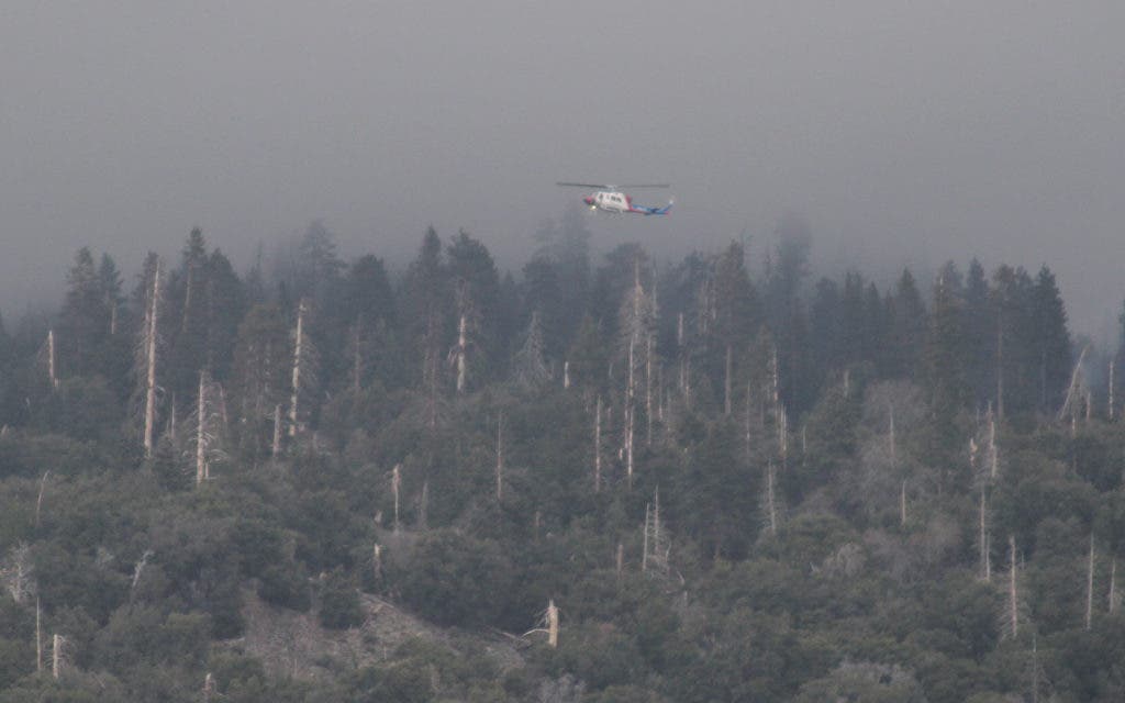
Dense cloud cover and fog prevented aircraft from flying the fire from Sunday afternoon to Tuesday afternoon.
Find out what's happening in Banning-Beaumontwith free, real-time updates from Patch.
Hard to see and hard to reach, the fire could burn for days to come, and it could take longer to ensure the main fire and all spot fires are completely out, a Forest Service spokeswoman said.
As of Tuesday evening, the fire was still estimated at about 150 acres due to limited reconnaissance of its size and spread, said Pam Bierce of the San Bernardino National Forest.
Find out what's happening in Banning-Beaumontwith free, real-time updates from Patch.
There were 147 personnel assigned to the fire, including firefighters and aircraft personnel staged at airfields in Hemet and Redlands, Bierce said.
The grounded aircraft included a helitanker, two medium helicopters, two air tankers, and one air attack lead plane.
About 4 p.m. Tuesday, the first helicopter flight on the fire in two days skirted cloud cover on a high ridge above Mill Creek Canyon, looking for helispot landing zones to insert crews, and to use in the event of emergencies.
"That's the first since Sunday afternoon," Bierce said. "They're looking for helispots and trying to get a size-up on the fire, because we've not been able to fly it with any kind of aircraft since Sunday afternoon, because of the weather conditions.
"Right now they're checking to approve spots for helispots up there so that they would have more access in case of emergencies, and to be able to insert crews to save on the three-hour hike in there," Bierce said.
"But we're still unable to fly most of it because of the clouds and the fog that's up in the higher elevations. It doesn't make it safe for flying."
Bierce spoke Tuesday afternoon at the incident command set up at the Momyer Creek and Alger Creek trailhead just west of Fire Station 99 in Forest Falls.
"The main fire is right on the ridge in front of us, and the pilot can't even see the main fire because the clouds are too thick there," Bierce said. "So he's trying to see some of the spot fires. We have two or three spot fires in addition to the main fire.
"We're hoping to get some intelligence from him but up until now we haven't been able to have any eyes on it or any firefighters able to go around the whole perimeter because of the dangers up there," Bierce said.
"There's a lot of snags, dead trees, falling debris, you know, the trees are burning and falling over."
"We have mass amounts of trees up there that were killed by the bug infestation that we had, the drought, all of that," Bierce said. "That's what the fire is burning and it's going to take a while to mop it up because they'll want to make sure all the hot spots are out. So it's going to be a long duration operation."
No injuries had been reported as of Tuesday evening.
There was one to two inches of patchy snow on the fire area Monday night and early Tuesday but it did not put the fire out, Bierce said.
"We're supposed to have warming for the next couple of days but then cooling again by the weekend," Bierce said. "The heat on it is what's going to dry everything out more quickly and might cause some more active fire. I don't know if we'll have what we had Sunday, but there's the possibility.
"That's why we're keeping an eye on it and the crews will be in there. They'll be working for days on this."
The cause of the fire was under investigation, Bierce said.
Scientists warned before devastating mountain fires in 2003 that drought and bark beetles had killed millions of trees in the San Bernardino National Forest, which straddles San Bernardino and Riverside counties.
More than a million dead trees have since been removed from mountain communities including Angelus Oaks, Forest Falls, Big Bear and Idyllwild.
But millions more dead trees remain standing and fallen in high mountain wilderness areas.
Get more local news delivered straight to your inbox. Sign up for free Patch newsletters and alerts.


