Community Corner
PLATES BREAK: What 8.9-Magnitude On West Edge Of Pacific Could Mean In The San Gorgonio Pass
"The 03/11/2011 earthquake (preliminary magnitude 8.9) near the east coast of Honshu, Japan, occurred . . . between the Pacific and North American plates." - USGS


A team of 70 urban search-and-rescue specialists with the Los Angeles County Fire Department were preparing late Friday to fly to earthquake-and-tsunami ravaged Japan, more than 5,500 miles west of the San Gorgonio Pass.
The death toll in Japan was already in the hundreds, and Japanese news media were quoting government officials who said it could rise to more than 1,000. An estimated 200 to 300 bodies were found along the waterline in coastal Sendai, according to international reports.
The Southern California search team preparing to leave for Japan included paramedics, six dog handlers and their search dogs, and technicians experienced with heavy-duty cutting tools, Los Angeles County Fire Inspector Matt Levesque said in a phone interview late Friday.
Find out what's happening in Banning-Beaumontwith free, real-time updates from Patch.
The distance from the Pass to Japan is great, spanning the world's widest ocean and the international dateline.
But the two far-flung places are connected by the Pacific and North American plates, which played a significant role in the magnitude-8.9 temblor that struck at 9:45 p.m. Thursday local time for residents of Banning and Beaumont.
Find out what's happening in Banning-Beaumontwith free, real-time updates from Patch.
According to the U.S. Geological Survey, "the 03/11/2011 earthquake near the east coast of Honshu, Japan, occurred as a result of thrust faulting on or near the subduction zone interface plate boundary between the Pacific and North American plates."
Dale Grant, a USGS geophysicist at the National Earthquake Information Center in Colorado, summed it up in simpler terms.
"The plates are always moving and this time it happened to break at that point," Grant told Banning-Beaumont Patch late Friday. "One of these days it's going to break at the San Andreas."
Grant said he'd never heard of an 8.9-magnitude quake on the southern San Andreas Fault, which cleaves the San Gorgonio Pass.
But scientists expect a big one here sooner than later.
'GORGONIAN KNOT'
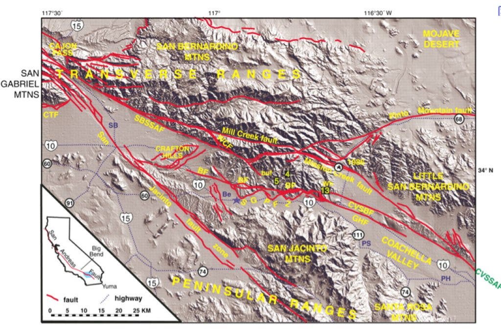
Rupture of the southern San Andreas Fault, from the Coachella Valley through the Pass to the Mojave Desert, is believed to be the greatest natural hazard California faces in the near future, according to the USGS.
"With an estimated magnitude between 7.2 and 8.1, such an event would result in violent shaking, loss of life, and disruption of lifelines - freeways, aqueducts, power, petroleum, and communication lines - that will bring much of Southern California to a standstill," according to Geophysicist Gary Fuis and other USGS scientists.
"The San Gorgonio Pass is an extension of the northern Coachella Valley," Fuis said in a phone interview this week. "Our studies will help us resolve what we call 'the Gorgonian Knot' - where the San Andreas splits into several branches.
"It's currently active out in the middle of the Pass," Fuis said. "The other branches are at the base of the San Bernardino mountains or within the San Bernardino mountains."
Named faults in the Pass include the San Gorgonio Pass Fault, the Banning Fault, the Mill Creek Fault, the Wilson Creek Fault and the Mission Creek Fault, Fuis said.
"The mountains are going up so fast, the Whitewater River has eroded into a spectacular cliff" east of Mill Creek Jumpoff, Fuis said.
Fuis and other USGS scientists this week were collecting seismic images of the earth's crust beneath the Coachella and Imperial valleys. The Salton Seismic Imaging Project seeks to map the underground geometry of the southern San Andreas Fault, and to measure the depth of sediments in the valleys.
How deep the sediments are can show how fast earthquake energy can travel through the sediments.
MOUNTAINS LOOM
The Pass is situated between the two highest points in Southern California, 11,499-foot San Gorgonio Mountain and 10,834-foot San Jacinto Peak.
If a large quake veers off the San Andreas and into the mountains, it could still wreak havoc in the Pass. Evidence of previous land movement in the San Gorgonio and San Jacinto high country is easy to find.
But the largest slide in the Transverse Ranges is the Blackhawk Slide on the north slope of the San Bernardino Mountains, according to geologists.
The prehistoric slide is also one of the largest in North America, Robert Norris and Robert Webb wrote in Geology of California.
"The end of the slide can be seen from State Highway 247, about 10 miles east of Lucerne Valley, but the only satisfactory way to see the entire slide is from the air," according to Norris and Webb.
The Blackhawk Slide is 5 miles long, about 2 miles wide, and 30 to 100 feet thick, and it came off Blackhawk Mountain about 4,000 feet higher in elevation, the scientists say.
About 17,000 years ago, a mass of limestone collapsed and slipped rapidly into upper Blackhawk Canyon, forming a stream of rubble about 2,000 feet wide and 300 to 400 feet deep, according to Norris and Webb.
As the slide moved down the canyon at about 170 miles per hour, it passed over a ridge that crosses the canyon, "and was thus launched into the air - a geologic version of a flying carpet," according to Norris and Webb.
The airborne slide was as high as 400 feet above the canyon floor, moving at speeds up to 270 miles per hour, and the distance from launching point to resting place was covered in about 80 seconds, according to their calculations.
Whether an earthquake was associated with the Blackhawk Slide has never been established. It occurred "presumably during a wet period," Norris and Webb noted.
But the Blackhawk and other slides that are visible from the Pass help illustrate the relative stability of mountains looming near Banning and Beaumont.
The San Gorgonios and San Jacintos, like all mountain ranges, were built in part by tectonic grinding and uplifting. The same forces that put them up can also help bring them down.
Get more local news delivered straight to your inbox. Sign up for free Patch newsletters and alerts.


